Visiting Iceland in the depths of winter might not sound logical, but if you can brave the chill, you’ll be bestowed with some of our world’s most magnificent scenery. Harsh winds and snowfall render many places in Iceland difficult to access in wintertime, but these three routes will guide you through the best of this veritable Viking wonderland.
The Golden Circle
Þingvellir · Geysir & Strokkur · Gullfoss · Laugarvatn · Flúðir
“The Golden Circle” is Iceland’s most well-known itinerary and is often taken by first-time visitors to the country. The route, which can be completed during a day, comprises several stops bearing geographical, historical, and even lexical significance.
Driving from Reykjavík, the first main highlight you’ll cross will be Þingvellir National Park, situated in a rift valley straddling the North American and Eurasian tectonic plates. Þingvellir (pronounced THING-vet-ler) literally means “parliament fields” and was where Iceland’s parliament used to gather between 930 and 1798.
A quick Icelandic lesson: The runic letter Þ/þ (called thorn) can be transliterated into th and is pronounced like in the word “earth.” Another Icelandic letter, Ð/ð (eth), is used to represent the softer th sound found in words like “this,” “that,” and “then.”
Next is the geothermal valley of Haukadalur (HOY-ka-da-lur), where you’ll find Geysir (GAY-sir), the hot water spring that lent its name to the English language in the 18th century. These days, the geyser stays quite dormant, but nearby Strokkur still spouts steaming jets into the air every ten minutes or so.
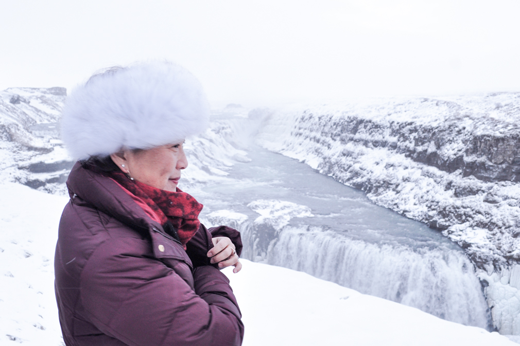
The most striking view along the Golden Circle is indubitably the one found at mighty Gullfoss, a ten-minute drive east from the geysers. It’s a stark contrast to the occasional erupting jets of boiling water and steam. Here, water gushes and plummets with a thunderous momentum into the canyon below.
A game of names: Icelandic names may seem intimidating, but paying a little extra attention to them can help you gain a better understanding of these locations’ significance in Icelandic culture and history. Many of the names are of a descriptive or ornamental nature. Gullfoss, for example, is the compound of two common nouns: gull, meaning “gold”; and foss, meaning “falls.”
The geothermal bath towns of Laugarvatn (LOY-gur-va-tn) and Flúðir (FLOO-thur) await travelers with a toasty welcome at the end of their tour around the Circle. Laugarvatn Fontana is a modern spa and wellness center comprising steam rooms built directly over hot springs, a series of mineral pools, a Finnish sauna, and lake access for those wishing to reap the therapeutic benefits of a polar dip. The Secret Lagoon in Flúðir is smaller and more austere, but it beautifully preserves the essence of bathing in an undisturbed, natural hot spring.
The Southern Coast
Seljalandsfoss & Gljúfrabúi · Skógafoss · Vík & Reynisfjara · Fjaðrárgljúfur · Jökulsárlón
The southern coast of Iceland hides a trove of wild and wintry landscapes. To truly appreciate the beauty of southern Iceland, allot yourself at least three full days for the drive and back. This itinerary follows part of Iceland’s Ring Road, a national road that circles the island, connecting the country’s most inhabited cities.
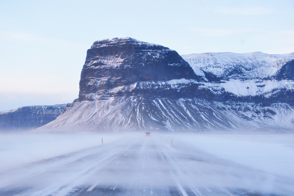
A word of caution: Before you begin, check the current road conditions for the stretch you plan to drive. Icy winds coming off the glaciers are not only strong, but they can also stir up snowdrifts that may greatly reduce visibility.
Start your journey across the south by chasing some of Iceland’s most stunning waterfalls. From the sleepy town of Selfoss—which has very possibly the country’s most delicious hot dogs, Iceland’s national fast food—drive eastward along the Ring Road until you reach Seljalandsfoss and its vertical, filament-like plunge. On a day with good weather, it’s possible to walk to nearby Gljúfrabúi (GLYOO-vra-boo-ee), a smaller cataract hidden behind a mountain crevice.
Further east, by the hamlet of Skógar, the waters of the river Skógá give their final performance, hurling over the highlands of Iceland before disappearing into the ocean.

You can admire the majestic Skógafoss from its base or from above: a hiking path to the right leads up the cliffside and drops the wanderer onto a soft, snowy plateau. (In summer, this path is a popular trekking route: it passes between the menacing Eyjafjallajökull and Katla volcanoes and then descends down the glacial valley of Þórsmörk.)

Continue onward and you’ll soon approach Vík, situated on the midpoint of southern Iceland. But just before that are the promontory of Dyrhólaey (DEER-ho-lay) and the black pebbled shoreline of Reynisfjara (RAY-nis-fya-ra)—considered to be one of the world’s most beautiful beaches. In place of palm trees, the piercing basalt pillars of Reynisdrangar strike an unforgettable impression, and the absence of color in the battering winter leaves a moody yet nostalgic imprint unto mind and memory.
In recent years, the tourism boom in Iceland and rising interest in Reynisfjara have led to the construction of a parking lot and café mere meters away from the beach, dispelling its sense of untethered remoteness.

The picturesque Vík í Mýrdal, which literally means the “bay in boggy dale,” is the southernmost point of Iceland and the largest settlement for miles. Aside from several hotel developments and a roadside cafeteria built along the Ring Road, Vík still retains a small-town atmosphere…for now. Its beach offers another postcard-perfect vista of the jagged sea stacks of Reynisdrangar, and as it’s the last proper town until Höfn—some 270 kilometers away—many travelers make Vík their base when exploring southern Iceland.

The terrain between Vík and Höfn (pronounced huhp) is untouched and desolate, but within it hides some of Iceland’s best and most quintessential. Close to the village of Kirkjubæjarklaustur (KIRK-yoo-bai-yar-kloy-stur), you’ll find the poetically named Fjaðrárgljúfur (FYATH-raur-glyoo-vur, from fjöður, “feather”; and gljúfur, “canyon”). Against a snowy backdrop, the sides of the canyon rise up above the icy river like a pair of long, outstretched wings. Strap on a pair of crampons and enjoy the view along the rim.
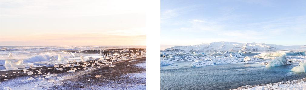
The glacial river lagoon of Jökulsárlón on the southeastern coast is one of nature’s most amazing wonders and a place that truly lives up to the name of Iceland. In a journey that’s said to last more than five years, large chunks of ice break off from the glacier of Breiðamerkurjökull and are gradually carried by meltwaters through the lagoon, down a short river, and into the open ocean. There, relentless waves pound the icebergs into smaller pieces, and they’re ultimately left to thaw away into the black sands of the outwash plain. The best time to visit is at dusk, when the sun’s waning light is just right, transforming the entire beach into a field of glistening diamonds.
In the area of Jökulsárlón, several companies offer guided ice cave tours and glacier walks on Vatnajökull, Iceland’s largest glacier. If you’re interested, be sure to make your reservation in advance.
Vesturland, The Western Region
Borgarnes · Kirkjufell · Búðir · Hraunfossar & Barnafoss · Húsafell & Langjökull
The Snæfellsnes Peninsula in Iceland’s Western Region is in no lack of beauty. It offers an array of natural attractions, from dramatic coastlines to hidden hot pools to snow-capped volcanoes. Its largest mountain, the Snæfellsjökull volcano, is also the setting of Jules Verne’s Journey to the Center of the Earth. Reserve at least two days for driving around the peninsula, as light is sparse this far north during the winter. For a chance to walk inside a glacier or to see the northern lights, add an extra day or two to your trip and venture into the inner Vesturland.
Driving north from Reykjavík, you’ll first pass by the town of Borgarnes. Switch gears for a while and spend some time indoors over at The Settlement Center. You’ll learn about the settlement of Iceland by the Vikings and also hear about the life of Egill Skallagrímsson, a warrior-poet whose adventures across Iceland, Norway, and England are recounted in the eponymous Egil’s Saga.

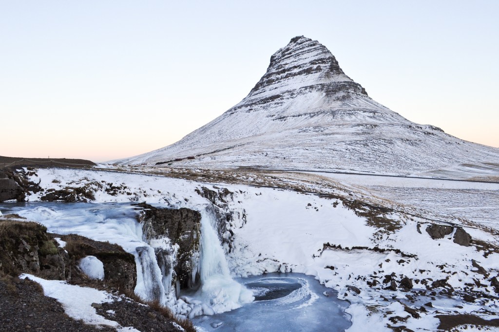
From Borgarnes, leave the Ring Road and drive in the direction of Grundarfjörður, found on the peninsula’s northern side. As you make your approach from the east, the mass of mountains behind the village slowly takes on a new, enchanting shape, coming together and fusing into a singular ascent. This is Kirjkufell, one of Iceland’s most iconic mountains and magical places. On the brim of this bewitching mount is a scene that will surely steal your breath away. Under an infinite firmament, submerge yourself in the pure magic of Iceland and watch the waters of Kirkjufellsfoss cascade into their frosty, cornflower-blue pool.
The coast of the Snæfellsnes Peninsula is speckled with natural attractions. From Kirkjufell, continue driving toward the peninsula tip, where you’ll find the black shores of Djúpalónssandur. Not too far away, you’ll spot the recognizable lava neck of Lóndrangar, which somewhat resembles the basalt stacks by Reynisfjara. The quaint hamlet of Hellnar is a good spot for a coffee break and to get an impression of the old Icelandic way of life, which in centuries past centered primarily around fishing. And in the neighboring village of Arnarstapi, one will find the rock arch of Gatklettur with its scaly formations amidst a rough and storm-like setting.

As you conclude your tour around the Snæfellsnes Peninsula, keep your eyes peeled for Búðir, which is no more than a country hotel and tiny, wooden church. But good things come in small packages, and as tiny and unassuming as it might be, Búðir might just be one of the most beautiful places found anywhere in Iceland. With poise, dignity, and a certain sense of somberness, the black widow of Búðir looks vigilantly over Iceland’s wild west.
The inner region of West Iceland is quiet, remote, and perfect for those seeking a relaxed and easygoing experience. Between Borgarnes and the village of Húsafell is Europe’s most powerful hot spring, Deildartunguhver, where boiling water pumps out of the ground at over 180 liters per second. Even still, man has succeeded in harnessing this literal force of nature. The recently opened Krauma mixes hot water from Deildartunguhver with a cold mountain source to create a warm winter refuge of geothermal pools and natural steam baths.
Unlike the towering waterfalls of South Iceland and the Snæfellsnes Peninsula, the rivulets of Hraunfossar by Húsafell are spread over almost a kilometer and seep out from a porous lava field. (Logically, Hraunfossar means “lava falls.” Illogically, hraun is pronounced like “groin.”) A few minutes away is Barnafoss (“children’s falls”), a smaller waterfall that is the setting of an old Icelandic legend about two boys that fell into the falls and drowned. Upon discovering their fate, the mother cursed the stone bridge from which they fell, swearing that anyone else who crossed the falls would suffer the same fate as her beloved children.
Quiet little Húsafell is the point of departure for those wishing to explore the ice caves of Langjökull, Iceland’s second largest glacier after Vatnajökull. Its secluded location also makes it one of the best places to wait for the ethereal aurora borealis.
The ancient Icelanders held the northern lights in the highest of regards, believing them to be omens from the gods. If the lights danced vividly across the heavens, then bad weather was sure to come; if the color of the lights were red, they warned of an impending volcanic eruption. While we’ve since unraveled the mystery behind the aurora and can even forecast to an extent their appearance, the northern lights are still a marvel to behold now as they have been for centuries past.

For anyone who wishes to visit Iceland in winter, the Golden Circle, the southern coast, and Vesturland together form a vibrant itinerary that traverses the island’s most captivating landscapes. Complement your road trip with several days exploring Reykjavík’s lively gastro scene and you will quickly come to understand why so many people call this island their favorite destination on earth.

Leave a comment